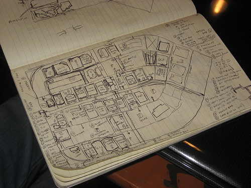
This is the survey log book of OpenStreetMap user seav and
demonstrates that great mapping can be done with a keen eye, a steady
hand and little in the way of high technology. Until you are ready to
edit and upload.
This page of the log book shows this area of the map.
http://www.openstreetmap.org/?lat=14.5875&lon=121.06185&zoom=17&layers=B000FTF
The photo was taken by OSM user maning, during the Ortigas-Mandaluyong
Mapping Party.
http://wiki.openstreetmap.org/wiki/Ortigas-Mandaluyong_Mapping_Party
Log book photo by OSM user maning http://wiki.openstreetmap.org/wiki/User:Maning
is licensed CC-By-SA http://creativecommons.org/licenses/by-sa/3.0/
This is a Featured image, which means that it has been identified as
one of the best examples of OpenStreetMap mapping, or that it provides
a useful illustration of the OpenStreetMap project.
If you know another image of similar quality, you can nominate it on
http://wiki.openstreetmap.org/wiki/Featured_image_proposals
I am confused, and must admit I don’t understand OSM as well as I’d like: was this hand drawn map scanned in or otherwise used to populate the online map?
I don’t know this mapper’s exact process, but when I use paper like this I use it as a guide when I am using Yahoo imagery to trace. Now he may have scanned it as well, but the coordinates that would be on the final map would be based on Yahoo imagery and GPS points, not this map.
Hi guys, I’m the mapper who did this sketch. The area corresponds to this place: http://osm.org/go/4zhHfYwbS-This sketch was not scanned (not like Walking Papers) but used as a source of notes for names, POIs and stuff like that. This was not used to derive absolute positioning. 🙂